Queensland Floods

Toowoomba is a bit of a mess, but Brisbane may yet be even worse.


TWBA_Floods_2011_01.jpg

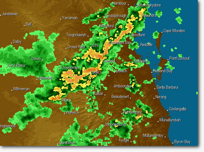
Rainfall @ 6.00 am this morning (Queensland Time)


TWBA_Floods_2011_02.jpg

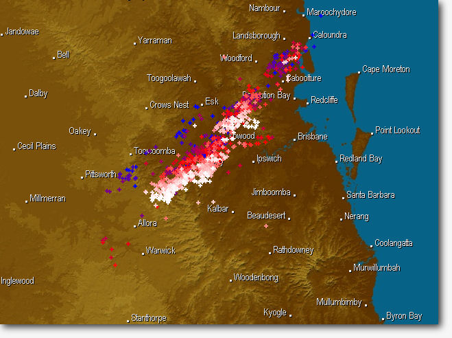
Then the storms really started. This is the lightning map an hour later.
 
I am currently in shock over what is happening in SE Queensland at the moment ...

There is an utter disaster unfolding in real-time on FB and Twitter. Queensland Police report 8 dead 72 missing from the "inland Tsunami" that went through Toowoomba and Lockyer valley last night, all that water is now heading downstream to Ipswich and Brisbane ...

Very tragic. These could be the worst floods in our history.
 
Yes. The Bureau of Meteorology has just issued a 12-hour warning for the Bremer River at Ipswich of 17-18 metres, which is the same level as during the devastating floods associated with Tropical Cyclone Wanda in January, 1974.

Added to this, Wivenhoe Dam on the Brisbane River is now releasing at maximum.

Brisbane is going to get seriously messed up.
 
Very tragic. These could be the worst floods in our history.

In recorded history, absolutely. Australia is fortunate they nagivated the financial crisis well as this is going to be devastating to agriculture. Years of drought followed by this is going to have wiped out a lot of topsoil. Coal mines are all full of water which will take weeks to empty. Train and road travel is going to be stopped or limited for weeks.

I'm sitting here in Sweden feeling rather helpless, SE Queensland is the part of the world I grew up in and most of my family remains. :( Fortunately they're all safe. So far.
 
Last edited:
Yes. The Bureau of Meteorology has just issued a 12-hour warning for the Bremer River at Ipswich of 17-18 metres, which is the same level as during the devastating floods associated with Tropical Cyclone Wanda in January, 1974.

Added to this, Wivenhoe Dam on the Brisbane River is now releasing at maximum.

Brisbane is going to get seriously messed up.

Yup, that Bremer peak is an upward revision of 3-4 metres on what they'd put in to their projections earlier today for Brisbane flooding, which had several hundred houses needing evacuation and a couple of thousand predicted to flood.

Add that "error" in to the rest of the catchment and there's a serious problem. Wivenhoe is all that's stopping an absolute catastrophe in Brisbane.
 
If anyone is familiar with the road down the range from Toowoomba towards Brisbane, check out this photo and think about what happened at the bottom ...


I come from Toowoomba and I know exactly what happened. At the bottom of that hill is Withcott and last night a house crashed into the Pub there.
 
It certainly is. It's given people precious time to get organised.

And so it begins ... Police have just called for evacuation of lower parts of West End in Brisbane

And this, from an hour or so ago on the BOM website, a new current warning -

TOP PRIORITY FOR IMMEDIATE BROADCAST
SEVERE WEATHER WARNING
for heavy rainfall leading to localised flash flooding and worsening the
existing river flood situation
For people in the Southeast Coast District and the Darling Downs and Granite
Belt District southeast of Dalby to Goondiwindi.
 
Got my only ever speeding ticket at the bottom of that hill. :(


I have a whole sheaf of them. :)

The up section is closed today by a landslide that happened yesterday. Another one has closed the New England Highway to the North but I'm not sure where. The highway south is closed and Warwick is under serious threat and to the West you can't get much further than Pittsworth.
 
And so it begins ... Police have just called for evacuation of lower parts of West End in Brisbane

And this, from an hour or so ago on the BOM website, a new current warning -

TOP PRIORITY FOR IMMEDIATE BROADCAST
SEVERE WEATHER WARNING
for heavy rainfall leading to localised flash flooding and worsening the
existing river flood situation
For people in the Southeast Coast District and the Darling Downs and Granite
Belt District southeast of Dalby to Goondiwindi.


I assume you're watching the radar as well. It's been belting down at Laidley since about 4:00am. The town centre is just starting to flood now.
 
I have a whole sheaf of them. :)

I was doing 180 , so I can't complain :)

I think that gets instant loss of licence these days.

In my defence I was running late for work. Which I suppose isn't a surprise since I worked in Herston, Brisbane, and woke up from a party at the Vet School in Goondiwindi .... :cool:
 
Last edited:
In my defence I was running late for work. Which I suppose isn't a surprise since I worked in Herston, Brisbane, and woke up from a party at the Vet School in Goodiwindi .... :cool:


For the foreigners, this is a distance of 11,000 miles and is in another state.

People forget how big Australia is sometimes..
 
I assume you're watching the radar as well. It's been belting down at Laidley since about 4:00am. The town centre is just starting to flood now.

Hadn't actually. Looks like a lot of this new rain is going to be outside Wivenhoe catchment, which is not going to help.
 
For the foreigners, this is a distance of 11,000 miles and is in another state.

People forget how big Australia is sometimes..

lol! Not quite, but it is on the border and about 350km.

It was a good party :D

I drove to Canberra for a party one weekend. We were a little late. We got held up by an F-111 on the highway outside Gatton. Nobody believed us!
 
Ipswich mayor now says expect peak 19m+.

Wivenhoe was at >145% capacity and Somerset 150% yesterday before all this happened. Wivenhoe can apparently cope with 250% if necessary.
 

Back
Top Bottom