You are using an out of date browser. It may not display this or other websites correctly.
You should upgrade or use an alternative browser.
You should upgrade or use an alternative browser.
Queensland Floods
- Thread starter HawaiiBigSis
- Start date
So I understand that Queensland is pretty much a gihugic lake right now...
Is everybody okay?
Because Australia is pretty flat, any floods sneak up on you gradually. The only people who get in trouble in floods are those who ignore warnings and try to drive through fords and get washed away. The only Queensland forumites I know of are in Brisbane, which is safe.
HawaiiBigSis
List Management
Because Australia is pretty flat, any floods sneak up on you gradually. The only people who get in trouble in floods are those who ignore warnings and try to drive through fords and get washed away. The only Queensland forumites I know of are in Brisbane, which is safe.
Yeah, people who ignore warnings and try to drive through fords deserve what they get...
The pictures I was seeing were people in boats floating past their houses, and that didn't seem as though they asked for it.
")
MG1962
Unregistered
- Joined
- Sep 27, 2006
- Messages
- 17,252
Because Australia is pretty flat, any floods sneak up on you gradually. The only people who get in trouble in floods are those who ignore warnings and try to drive through fords and get washed away. The only Queensland forumites I know of are in Brisbane, which is safe.
Yeah well I remember what happened in Victoria last time Queensland flooded...was not pretty
HawaiiBigSis
List Management
So a little bit of googling indicates that Queensland floods pretty often.Yeah well I remember what happened in Victoria last time Queensland flooded...was not pretty
Isn't there some sort of water containment system in place?
(And what happened in Victoria the last time Queensland flooded?)
Alan
Illuminator
- Joined
- Oct 22, 2009
- Messages
- 3,714
I think he means the Black Saturday bushfires.
http://en.wikipedia.org/wiki/Black_Saturday_bushfires
http://en.wikipedia.org/wiki/Black_Saturday_bushfires
Kid Eager
Philosopher
- Joined
- Nov 5, 2010
- Messages
- 7,296
So a little bit of googling indicates that Queensland floods pretty often.
Isn't there some sort of water containment system in place?
(And what happened in Victoria the last time Queensland flooded?)
Yes, there are dams where geography permits, but where's there's lots of flatness there's nowhere to put dams. You throw a bucketload of rain at a flat area with not much drainage and bad things happen.
What makes it more difficult is the El Nino - La Nina cycle, which has us alternating between long periods of drought, broken by heavy rain. Drought one minute, standing on the roof watching floodwaters go by the next....
Lake Eyre is Australia's lowest point, in the middle of South Australia. It is usually a dry salt basin, and there have been several land speed record attempts there. It's now getting close to it's highest water level, and these floods will eventually find their way there. I'd love to go there sometime when it's full.So a little bit of googling indicates that Queensland floods pretty often.
Isn't there some sort of water containment system in place?
(And what happened in Victoria the last time Queensland flooded?)
http://en.wikipedia.org/wiki/Lake_Eyre
Akhenaten
Heretic Pharaoh
So a little bit of googling indicates that Queensland floods pretty often.
You could say that
Here are the ingredients:
The highest point in Queensland is Mount Bartle Frere. It's part of the Great Dividing Range which runs parallel to and not far inland from Australia's East coast, from Coen in Far North Queensland all the way down to where I live in Victoria.

Mount Bartle Frere
It's only 1,622 m (5,321 ft) high, which isn't much compared to, say, Mauna Kea's 4,205 m (13,796 ft), especially when you consider the area of the state that it doesn't quite tower over.
The area of Queensland is 1,852,642 km² (715,309 sq mi). Compare this to Alaska - 1,717,854 km² (663,268 sq mi) or France - 674,843 km² (260,558 sq mi).
The vast majority of it looks like this:

Thargominda
or this:

Camooweal
It's not all flat . . .

Mountains!
December-March is usually considered Monsoon season, it can start as early as November and run as late as April
Here are some rainfall figures from four major cities:
City
||
Rainfall
||||
|Brisbane||1,149.1 mm (45.24 in)|
|Townsville||1,136.7 mm (44.75 in)|
|Mackay||1,570.7 mm (61.84 in)|
|Cairns||2,006.3 mm (78.99 in)|
When all of that is added up together, you get this:
Isn't there some sort of water containment system in place?
'Course there is.

The Weir at St George
Umm . . . yeah . . . well, moving right along . . .
(And what happened in Victoria the last time Queensland flooded?)
I think he means the Black Saturday bushfires.
http://en.wikipedia.org/wiki/Black_Saturday_bushfires
Yep.

HawaiiBigSis
List Management
Oh, I remember the brushfires... but they weren't really related to the rain half a continent away, were they? (Except by accident of the calendar?)
And well, that's sorta the situation in the Los Angeles Basin as well. Pretty much flatland with a few hills poking up here and again. Long ago they created a drainage system to accommodate the occasional flood, so as to allow people to build houses in the (mostly, usually) dry riverbeds.
I won't say that it's been an unequivocal success, but it's helped some...
Magenta
Graduate Poster
- Joined
- Sep 16, 2007
- Messages
- 1,305
Oh, I remember the brushfires... but they weren't really related to the rain half a continent away, were they? (Except by accident of the calendar?)
Not causally related. In terms of climate change though, southern Australia is getting drier and the north wetter.
And well, that's sorta the situation in the Los Angeles Basin as well. Pretty much flatland with a few hills poking up here and again. Long ago they created a drainage system to accommodate the occasional flood, so as to allow people to build houses in the (mostly, usually) dry riverbeds.
In Queensland we just build our houses (or used to) up on stumps to allow for the occasional inundation.
But sometimes there's too much water. All sorts of weather records have been broken lately. In Brisbane where I live we've just had the wettest December for 150 years (450mm). This Bureau of Meteorology map shows the December rainfall anomalies (variation from the long term average) for Queensland. And that comes after the wettest spring since records began in 1900.
The topography means that these river systems have vast catchment areas. Comparing this catchment map of Queensland with the current flood warnings shows the area currently affected. The Fitzroy River system alone is huge and the flood peak has not yet reached Rockhampton.
As bad as these floods are, at least the evacuations (sometimes of whole towns) have been more or less orderly and there is government financial assistance available for those affected, many of whom won't have flood insurance. It did make me reflect on the Pakistan floods and wonder what had become of the millions of people affected, many of whom appeared to have very little to begin with.
Last edited:
HawaiiBigSis
List Management
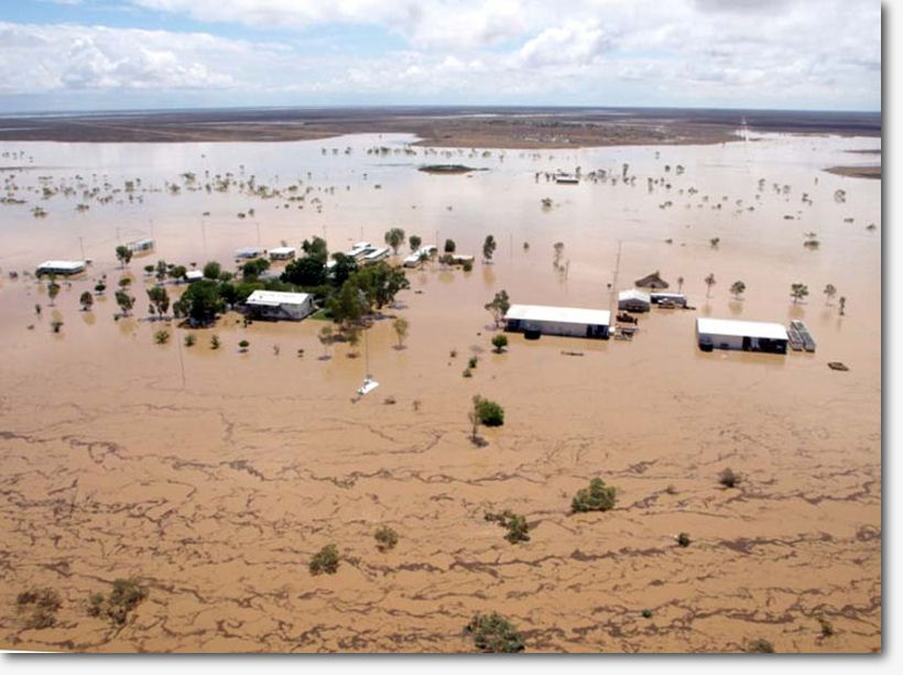
And Rockhampton goes under...
Akhenaten
Heretic Pharaoh
arthwollipot
Observer of Phenomena, Pronouns: he/him
Sideroxylon
Featherless biped
Map supplied by Bob Katter?
Magenta
Graduate Poster
- Joined
- Sep 16, 2007
- Messages
- 1,305
Some excellent photos from NASA satellites showing the flooding in the Fitzroy River basin. Interesting contrast between images from December and January.
http://earthobservatory.nasa.gov/NaturalHazards/view.php?id=48420
http://earthobservatory.nasa.gov/NaturalHazards/view.php?id=48420
Akhenaten
Heretic Pharaoh
Some excellent photos from NASA satellites showing the flooding in the Fitzroy River basin. Interesting contrast between images from December and January.
http://earthobservatory.nasa.gov/NaturalHazards/view.php?id=48420
Geeze, that's an awful lot of water.
Akhenaten
Heretic Pharaoh
My Daughter in Toowoomba said:I'm home now and drying out but ...it is just devastating what's happened here. I just can't believe it.
There's no way out of town, there's been landslides on the Range and on the roads out to the north, everything West is flooding, and so is the south.
Some of my friends who work in the city watched cars washed down the road with people trapped inside. That's what you would've seen on the news. These are streets I drive and walk all the time and they've just been washed away.
And guess what?! IT'S STILL <naughty word> RAINING!
http://www.abc.net.au/news/stories/2011/01/11/3110095.htm
http://www.abc.net.au/news/stories/2011/01/11/3110113.htm
http://www.abc.net.au/news/video/youtube.htm?v=D7HLvwPmles